

Please remember tomorrow, December 3rd, the Worcester Massachusetts six firefighters who died in the line of duty at the tragic Worcester Cold Storage Warehouse fire on December 3, 1999. Never Forget.

FOLLOW ALL INCIDENTS AS THEY ARE DISPATCHED ON TWITTER
You can now follow all the incidents that we dispatch via Twitter. You need to have a Twitter account. After you are signed in to your Twitter account, click on this link Click Here for the link and click on "follow". You can get these sent to your phone by a text message if you set your phone to receive the text on your Twitter Account.
CHESHIRE COUNTY FOREST FIRE WARDENS MEETING AND DINNER
Cheshire County Forest Fire Warden's Dinner and meeting will be Tuesday, December 4th at the church in Nelson. Dinner at 1900 hours, meeting at 2000 hours, and Yankee Swap to follow. Also a reminder for all members to submit up to date contact info to the Secretary as we are updating our by-laws and all members must be notified.
A NEW TOOL FOR OUR RESPONDERS
You can now see the live activity at Southwestern NH District Fire Mutual Aid Dispatch Center on line.Simply click on the following link: Click here for the link
Under connect to your department, click on the link in small print that says, click here for a list of active agencies. Then click on Southwestern NH District Fire Mutual Aid. The active calls that are in progress will show on your screen. You will see the street the call is on, the cross streets (if provided), the type of call, times, and responding units. If you click on “Show Details†you will see the units status and a Google map will be displayed showing on the map the location of the call. To hide the details, click on “Hide Details†and the details will go away. The calls you are seeing are actual calls that are going on. When the call is finished, the information for that call will go away. This site refreshes automatically. Our responders can actually save this web site to their smart phones and use this as a tool. We are dedicated to providing the most up to date tools in the industry to further support our responders.
WILMINGTON MVA LEAVES ONE DEAD
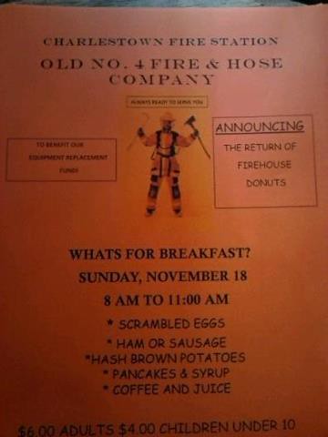
Charlestown FD Breakfast
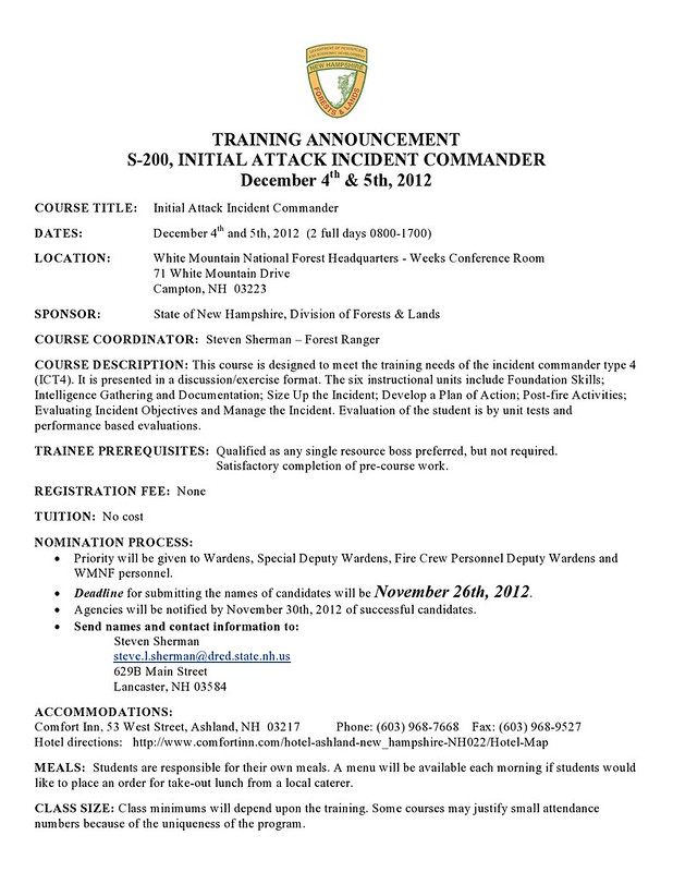
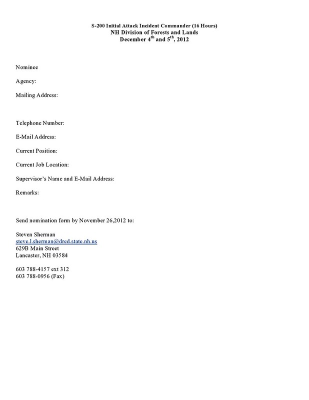
S-200 Course
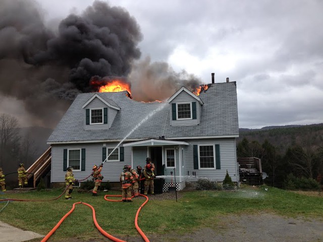
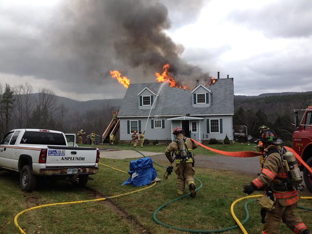
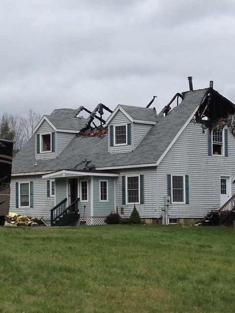
SECOND ALARM FIRE IN ALSTEAD 11/1/2012
149 Alstead Center Rd (Rte 12A) Dispatchers on duty: Lt. Matt Yeatman, Lt. Ed Mattson, Dispatcher Kassie Dupre. Photos provided to Fire Mutual Aid.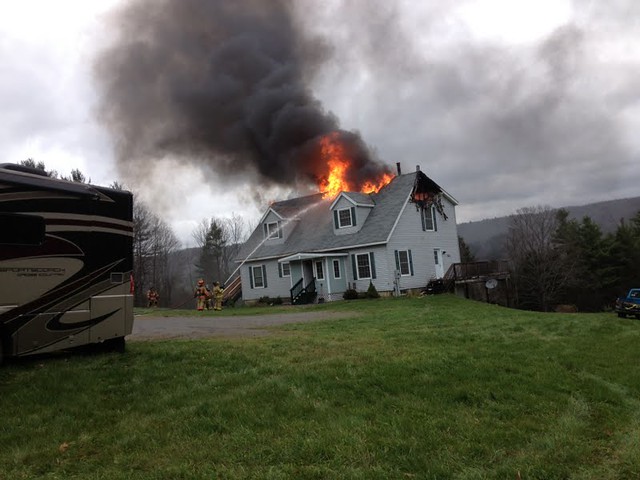
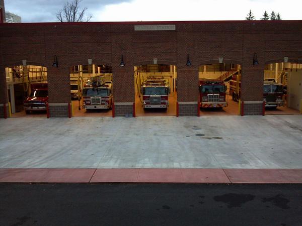
Its OFFICIAL!!!
The new Central Fire Station is open in Keene.Fire Mutual Aid now gets the old fire station as it's new headquarters.
VERMONT WEATHER UPDATE
THE NATIONAL WEATHER SERVICE CONTINUES TO CLOSELY MONITOR THEPROGRESS OF HURRICANE SANDY. THE LATEST OFFICIAL FORECAST TRACKS THE CENTER OF SANDY OVER EXTREME SOUTHERN NEW JERSEY OVERNIGHT. HIGH WIND WARNINGS REMAIN IN EFFECT FOR THE ENTIRE REGION AND A FLOOD WATCH REMAINS IN EFFECT FOR MOST OF EASTERN NEW YORK AND ALL OF ADJACENT WESTERN NEW ENGLAND. AS A REMINDER...IT IS IMPORTANT NOT TO FOCUS ON THE EXACT CENTER AND TRACK OF SANDY AS THIS STORM WILL BE QUITE LARGE AND POWERFUL.
FLOODING IMPACTS...RAINFALL COULD BE EXCESSIVE ACROSS PORTIONS OF EASTERN NEW YORK AND ADJACENT WESTERN NEW ENGLAND...ESPECIALLY ACROSS THE HIGHER TERRAIN. IF YOU LIVE IN A FLOOD PRONE AREA...BE PREPARED IN THE EVENT OF A FLASH FLOOD OR MANDATORY EVACUATION. LISTEN TO YOUR LOCAL EMERGENCY OFFICIALS AND BE ESPECIALLY ATTENTIVE TO ROAD CLOSURES.
DAMAGING WIND IMPACTS...WIND GUSTS UP TO 65 MPH ARE EXPECTED IN THE VALLEYS...AND UP TO 75 MPH OVER THE HIGHER TERRAIN. THESE WIND SPEEDS WILL RESULT IN DAMAGE TO TREES AND POWER LINES. ITEMS LEFT OUTDOORS MAY BECOME EXTREMELY DANGEROUS PROJECTILES. ALSO WIDESPREAD POWER OUTAGES ARE EXPECTED.
COMMUNICATIONS...OUR MEDIA PARTNERS...SOCIAL MEDIA AND THE INTERNET WILL KEEP YOU INFORMED. YOUR LOCAL NATIONAL WEATHER SERVICE IS AVAILABLE ONLINE AT 1. WEB PAGE WWW.WEATHER.GOV/ALBANY 2. FACEBOOK WWW.FACEBOOK.COM/US.NATIONALWEATHERSERVICE.ALBANY.GOV AND 3. TWITTER TWITTER.COM/NWSALBANY.